There must be an exchange of territories. The Pan-Arab corridor must be beneficial to the Arabs.
Once more about the land of Moriah
Sep. 6th, 2018 07:19 am83 And Sarah laid her head upon the bosom of one of her handmaids, and she became as still as a stone.
84 She afterward rose up and went about making inquiries till she came to Hebron, and she inquired of all those whom she met walking in the road, and no one could tell her what had happened to her son.
85 And she came with her maid servants and men servants to Kireath-arba, which is Hebron, and she asked concerning her Son, and she remained there while she sent some of her servants to seek where Abraham had gone with Isaac; they went to seek him in the house of Shem and Eber, and they could not find him, and they sought throughout the land and he was not there.
86 And behold, Satan came to Sarah in the shape of an old man, and he came and stood before her, and he said unto her, I spoke falsely unto thee, for Abraham did not kill his son and he is not dead; and when she heard the word her joy was so exceedingly violent on account of her son, that her soul went out through joy; she died and was gathered to her people.
87 And when Abraham had finished his service he returned with his son Isaac to his young men, and they rose up and went together to Beersheba, and they came home.
88 And Abraham sought for Sarah, and could not find her, and he made inquiries concerning her, and they said unto him, She went as far as Hebron to seek you both where you had gone, for thus was she informed.
89 And Abraham and Isaac went to her to Hebron, and when they found that she was dead they lifted up their voices and wept bitterly over her; and Isaac fell upon his mother's face and wept over her, and he said, O my mother, my mother, how hast thou left me, and where hast thou gone? O how, how hast thou left me!
https://www.sacred-texts.com/chr/apo/jasher/23.htm
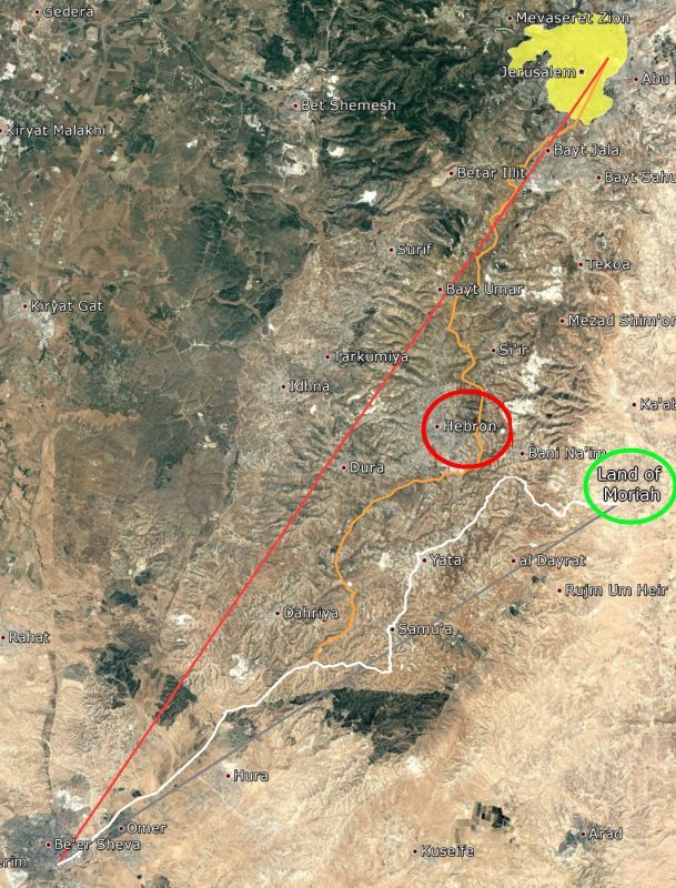
Yes, of course, Abraham could not meet Sarah on the way back, because he was going not from Jerusalem, but from the Judean desert, where the land of Moriah is located.
( Read more... )
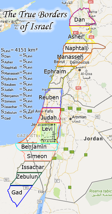
The True Borders of Israel
May. 16th, 2018 12:13 pmI do not presume to speculate on what boundaries Israel will have in future times, when all the nations will dream to be in the range of Israel. But today, when we build the Third Temple in accordance with the prophecy of Ezekiel, the boundaries of Israel must be this:
I also do not presume to decide where the descendants of the Canaanites, who are now occupying the Holy Land of Israel, must go. My purely personal opinion is that the Canaanites must be exterminated according to the Word of God. I also think that every person and every nation who will argue with the Word of God recorded in the Holy Scriptures will not be able to stand against Israel when Israel begins to obey the Word of God.
Therefore, I am optimistic about the future, expecting in the very near future unprecedented upheavals for the peoples of the earth. I await the Great Tribulation, the torment of the birth of the Messiah, Israel in the form in which He will rule over all mankind.
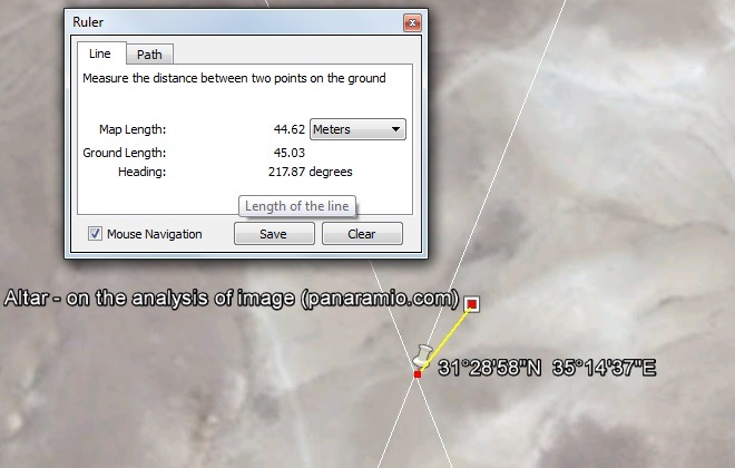
After combining the model with the terrane, I noticed a dark spot about 45 meters east of the altar. I think that this is a scattering of stones, left from the ancient altar of Abraham, in the place of Jehovah Jireh. Then the Temple model needs to be moved slightly to the east, so that the new altar is in place of the former altar.

Since I can not be sure that this dark spot on satellite photography is the ruins of an ancient altar, I will not yet move the Temple model 48 meters to the east and 18 meters to the north. Although it seems that it would be more convenient if the northern wall is built a little to the north than it is now: there is a stream and the wall runs right in the center of its channel.
If it turns out that the dark spot on the satellite image is really the ruins of the ancient altar, then we should look for fragments of the bronze knife of Abraham concerning these ruins. The burial of the remains of the sacrificial ram should be where there will be a passage 20 cubits wide (Ezekiel 42:3), which is along the western wall of the temple complex, about 120 meters to the west and a few meters to the south of the center of the ruins of the altar.
3D terrain model and topographic data
Jan. 16th, 2018 02:21 am
Just in case, I uploaded topographic data to the site. Plot of land 3x3 km. A topographic map combined with a satellite photo from Google Earth, as well as isohypses and terrain, all in the form of a file for SketchUp.
3D model of Ezekiel's Temple with a terrain of 3x3 km and with a model of the outer wall of 1440x1440 m is now available for download.

Those who wish to enjoy the visualization of Ezekiel's prophecy can independently engage in animation using this 3D model of the Temple and terrain, corresponding to the real location of the future Temple. Of course, for high-quality visualization, you will have to make some elements of the model yourself: rails and grating fences, and you will also have to make quality textures and materials, because I did not give it due attention.
( Read more... )
The procedure for determining the exact location of the Third Temple
and determining the exact borders of Israel
in accordance with the prophecy of Ezekiel
and determining the exact borders of Israel
in accordance with the prophecy of Ezekiel
The general view of the holy allotment looks like this:

The area of the square with sides equal to 72 km should be inscribed in the limits of Israel from the eastern border passing through the Jordan, to the Mediterranean Sea. A rectangular ledge on the west side of the Sacred Land can partially intersect the coast line and go into the sea, because this territory in Ezekiel's prophecy is defined as the source of food for the Israelis who will work in the City. The sea can also be a source of food. It is not excluded also the option of creating an artificial mound in the sea, to create areas for agricultural land there.
An important note: Jerusalem must be within the boundaries of the holy allotment. We can take into account only the historical boundaries of Jerusalem, without taking into account the new administrative boundaries.
Next will be a detailed description of the procedure for determining the exact location of the Third Temple and determining the exact boundaries of the State of Israel in accordance with the prophesy of Ezekiel
( Read more... )
Unknown altar
Apr. 22nd, 2017 03:17 pmSo, in previous publications, the drawings of the temple complex of the future Ezekiel's Temple were published and the coordinates of the altar of the future Third Temple were determined in accordance with the same prophecy of Ezekiel. As it turned out, the Third Temple should be built in the Judean Desert, 30 km south of Jerusalem.
( Read more... )
( Read more... )