The procedure for determining the exact location of the Third Temple
and determining the exact borders of Israel
in accordance with the prophecy of Ezekiel
and determining the exact borders of Israel
in accordance with the prophecy of Ezekiel
The general view of the holy allotment looks like this:

The area of the square with sides equal to 72 km should be inscribed in the limits of Israel from the eastern border passing through the Jordan, to the Mediterranean Sea. A rectangular ledge on the west side of the Sacred Land can partially intersect the coast line and go into the sea, because this territory in Ezekiel's prophecy is defined as the source of food for the Israelis who will work in the City. The sea can also be a source of food. It is not excluded also the option of creating an artificial mound in the sea, to create areas for agricultural land there.
An important note: Jerusalem must be within the boundaries of the holy allotment. We can take into account only the historical boundaries of Jerusalem, without taking into account the new administrative boundaries.
Next will be a detailed description of the procedure for determining the exact location of the Third Temple and determining the exact boundaries of the State of Israel in accordance with the prophesy of Ezekiel
For work we need Google Earth Pro. I used the version of Google Earth Pro 6.2.2.6613, now everyone is offered a newer version. Do not forget that If you do not have a key, use your email address and the key. GEPFREE to sign in.
It's possible that you will need some time to learn all the features of this program, but it is not too complicated.
For the first stage of the work you will need a drawing of the holy allotment, made with a transparent background. It is more convenient to use a simplified view of the plan of the holy allotment, in the form of a simple square. For the convenience of further work, it is better for you to immediately make a markup for the three parts of the holy allotment, the ratio of width for these sections should be 1: 2: 2.

Such a drawing should be made as large as possible with the minimum possible thickness of the lines. I made a drawing of 5001x5001 px.
Download this picture in Google Earth Pro.

For ease of use, you should ensure that the direction to the north is exactly on the top of the screen. Before uploading an image, you can align the direction to the north by setting a placemark. Put the placemark somewhere in the middle of the territory on which you are to try on the image of the holy allotment. On the View tab, enter zero values for Heading and Tilt.

Jump the cursor to another input window, you will see, in this case, the alignment of the spatial orientation of the image of the Earth's surface along the grid will occur.
When we place the image of the holy allotment on the surface of the Earth, we will have to constantly switch to the Ruler tool:

We need to try to ensure that the size of the square was as accurate as possible to 72 km, do not forget to correctly set the choice of unit of measurement.
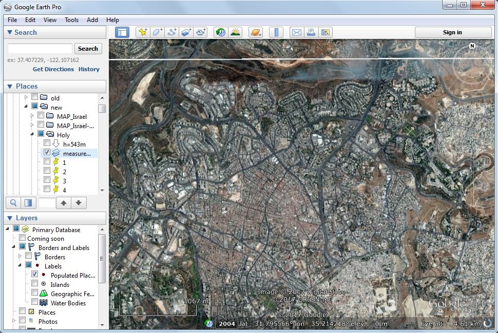
After when we have the required size of the square, we will move this square. With the help of a mouse wheel, we will approach different areas along the borders of this square, and we will move this square so that this square fits into the borders of Israel from the Jordan to the Mediterranean Sea, given the condition of finding the historical part of Jerusalem within the boundaries of our square.

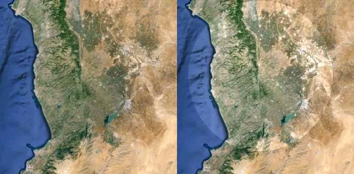
In the area of Ashdod, there are no special problems. In the Jerusalem area, we will have to look carefully at the pictures to try to correctly identify the ancient part of Jerusalem:
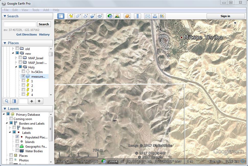
The northeast corner of the square of the holy allotment we determined was located near the highway in the Mitzpe Yeriho area:
In the area of Ein Gedi, the line of the coast of the Dead Sea crosses the boundary of the holy allotment:

Do not be afraid of it: in the prophecy of Ezekiel, this region is mentioned as a fishing place between Ein Gedi and Ein Eglaim (south of Ein Gedi).
And it shall come to pass, that fishers shall stand by it from En-gedi even unto En-eglaim; there shall be a place for the spreading of nets; their fish shall be after their kinds, as the fish of the Great Sea, exceeding many. (Ezekiel 47:10)
We determined the location of the southeast corner of the square of the holy allotment on the artificial embankment of the salt basin in the Ein Bokek area:
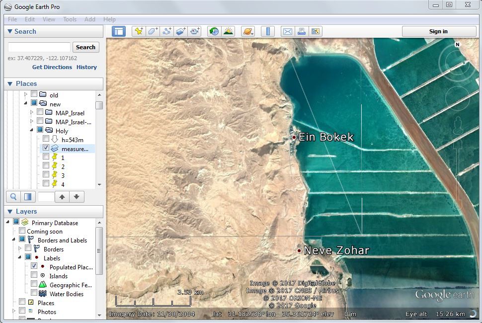
But the miry places thereof, and the marshes thereof, shall not be healed; they shall be given for salt. (Ezekiel 47:11)
The remaining sections of the boundary of the holy allotment should not cause special questions.
After we have placed the picture with the scheme of the holy allotment, we have to place placemarks on the corners and at the intersections with the boundaries of the areas of the Kohanim, the Levites and the possessions of the City.

This is quite a painstaking task: we constantly have to switch between the properties of placemarks and the measuring tool Ruler. When measuring, do not forget to control the azimuth.
Once we have placed the placemarks with satisfactory accuracy (accuracy of several tens of meters is quite acceptable), we use the Path tool to find the intersection point of the diagonals of the rectangular area that belongs to the Lord:

In the very center of this rectangle, the Third Temple should be built, according to the prophecy of Ezekiel.
And for these, even for the priests, shall be the holy offering; toward the north five and twenty thousand [in length], and toward the west ten thousand in breadth, and toward the east ten thousand in breadth, and toward the south five and twenty thousand in length; and the sanctuary of the LORD shall be in the midst thereof. (Ezekiel 48:10)
Turn on the Photos layer in the Layers window of Google Earth Pro.

We look at the picture taken near the intersection of the diagonals of the rectangle of the Lord:

Note that the coordinate label of this photo in Google Earth Pro is shown slightly to the north than the true place of its shooting. This can be easily verified by comparing the Bedouin sheds depicted in this photograph with satellite images.
But our attention should be drawn to a small pile of stones at the top of the hill, which in fact is the southern slope of a beautiful mountain, which we can see in other photos of Panoramio made in the vicinity of this place.
In the visions of God brought He me into the land of Israel, and set me down upon a very high mountain, whereon was as it were the frame of a city on the south. (Ezekiel 40:2)
Obviously, the pile of stones that we see in the photo is the ruins of an ancient altar. It is probably the altar of Abraham, who was in the land of Moriah (not to be confused with Mount Moriah!)
If the Israelis were not so indifferent to their biblical history, we would have had more pictures of this place. Perhaps some Israeli archaeologist would have found at a distance of about a hundred meters to the west of these ruins of the altar, under a large stoune, the remains of that ram, which became a sacrifice in exchange for Isaac.
Perhaps the archaeologists would have found there also fragments of that terrible knife that was raised in the father's hand over his beloved son. And with these insignificant debris, under the authority of which our whole history once was, the destiny of the entire Jewish people, the destiny of all the peoples of the world, today all the knives in the hands of terrorists with whom they are going to kill Jews, all the knives of terrorists would be destroyed to dust.
Because the confirmed place of the Third Temple, which the prophet Ezekiel saw, means that this Temple we will build today.
But lazy people pass by, travelers in the Judean desert travel far away this place, riding on their jeeps. How many more Israelis must die to find an archaeologist who will study these ruins?
When we found the place of the altar of Abraham, Jehovah Ira, we put a mark on the map from which the entire territory of Israel will be measured according to the prophecy of Ezekiel. To the north of the holy allotment there must be hereditary inheritance of the seven tribes of Israel, to the south of the holy allotment there must be the hereditary possessions of the five tribes of Israel.
Now we will determine the size of the area of land ownership for one tribe.
Hereditary tracts of land for each tribe of Israel must be equal to each other. The tribe of Levi includes the Levites and the Kohanim. The Kohanim is ruled by a piece of land owned by the Lord, but this does not change the case: in fact this is the land where the Levi tribe resides.
Using the Polygon tool, we create the shape of a rectangle that unites the land of Levites and Kohanim.

Google Earth Pro, unlike Google Earth, allows us to measure the area of a figure on the earth's surface.
The obtained area value, 4151 km², differs from the area of a flat rectangle with sides of 72 km and 57.6 km, which is equal to 4147.2 km² , because the Earth has a spherical shape.
So, every tribe of Israel should get a piece of land with a size of 4151 km².
Seven tribes in the north will receive 29 057 km² and five tribes in the south will receive 20 755 km². Together, the 12 tribes of Israel will receive 49 812 km². To this area it is necessary to add the area of the earth which is located between allotments of the earth in the north and allotments of the earth in the south.
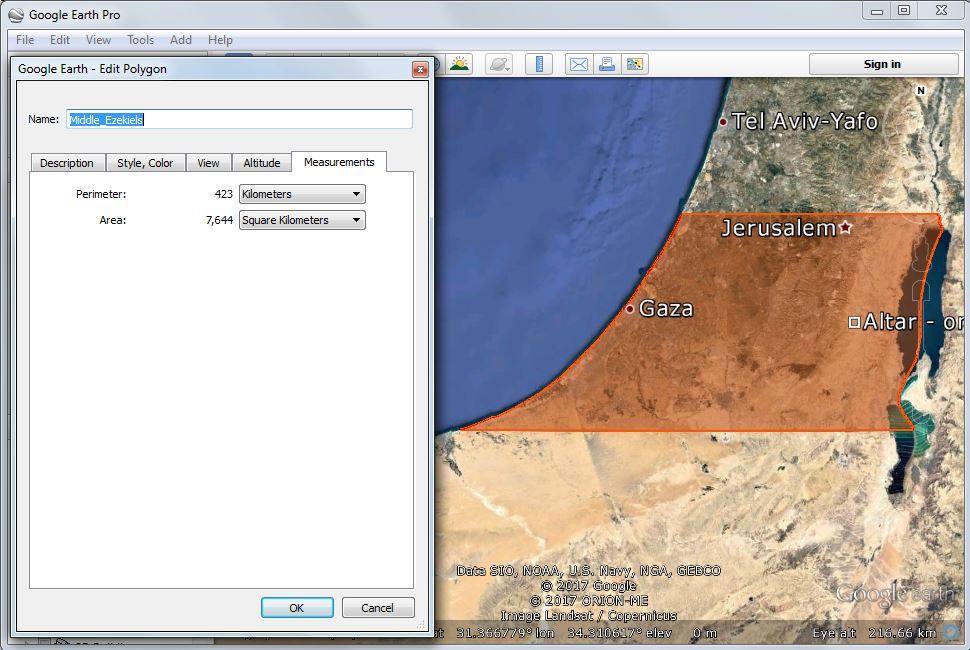
We got 7644 km². 7644 + 49 812 = 57456 km²
The territory of Israel in accordance with the prophecy of Ezekiel must be 57,456 km² .
Now it remains for us to determine the contours of Israel's borders in the north and in the south. We will rely on the prophecy of Ezekiel.
"This shall be the boundary of the land: on the north side, from the Great Sea by the way of Hethlon, to the entrance of Zedad;
Hamath, Berothah, Sibraim, which is between the border of Damascus and the border of Hamath; Hazer-hatticon, which is by the border of Hauran.
"The boundary shall extend from the sea to Hazar-enan at the border of Damascus, and on the north toward the north is the border of Hamath. This is the north side.
"The east side, from between Hauran, Damascus, Gilead and the land of Israel, shall be the Jordan; from the north border to the eastern sea you shall measure. This is the east side.
"The south side toward the south shall extend from Tamar as far as the waters of Meribath-kadesh, to the brook of Egypt and to the Great Sea. This is the south side toward the south.
"The west side shall be the Great Sea, from the south border to a point opposite Lebo-hamath. This is the west side.
(Ezekiel 47:15-20)
Let's start with the southern part.
When the prophecy said about the brook of Egypt (Wadi El-Arish), we must look at the entire length of his bed, not only on the lower reaches. Therefore, the place that people show us as Meribath-kadesh is complete nonsense. The place of Tamar is well known, Wadi El-Arish is also clearly visible in pictures from space, but we can for now only guess where Meribath-kadesh is located.
If you trace the contours of Wadi El-Arish, and from its source in the Sinai mountains to draw a straight line to Tamar, which is located near the southern part of the Dead Sea, the area of the figure will be almost equal to the total area of the land plots of the southern tribes of Israel.
That is, Meribath-kadesh is located somewhere very close to a straight line segment, drawn from the source of Wadi El-Arish to Tamar.
Studying local geographical names, I turned attention to the moshav Ein Yahav. "Ein" should mean "source," and the name Yahav in Hebrew begins with the first two letters of the Tetragrammaton and is phonetically very close to the Name of God.
When I laid the line from the source of Wadi El-Arish to Tamar via the moshav Ein Yahav, the result of measuring the area of the southern part of Israel almost completely coincided with the calculated value of 20 755 km ².

I also checked other options, for example, if Meribath-kadesh is located in the Eilat area. In all other cases, in addition to using the entire length of the brook of Egypt (Wadi El-Arish) and the straight line to the moshav Ein Yahav, the measured area values have very large deviations from the calculated ones.
So, we got the outlines of the southern part of Israel. Israel will have to give to neighbors Eilat, but instead Israel should take over the entire right bank of the Wadi el Arish.
For such is the will of the Lord ...
When determining the boundaries of the northern part of the territory of Israel, we should remember the usual ways of drawing boundaries along watersheds or along river beds.
Of the geographical names listed in the Ezekiel prophecy, there are no doubts about the names of the Syrian cities of Hamath (Hamah), Zedad (Sadad), Hazar-enan (Al Quaryatayn).
The name Sibraim (Two Hills), as described in the prophecy of Ezekiel somewhere between the regions of Damascus and Hamath, is easily identified when studying the real relief of a wide valley located on the road from Jerusalem to Zedad. You can see these Two Hills themselves if you stand on the Earth's surface in the Google Earth Pro program.
I tried different variants of northern borders of Israel, trying to conduct lines on watersheds and riverbeds. The best coincidence with the calculated values is obtained when the Golan Heights are not the territory of Israel ... But the Golan Heights are not in the prophecy of Ezekiel, they are a clear deviation from the boundaries of Israel prescribed in the Bible.
So, Israel must give up the Golan Heights, but must take under its sovereignty the whole of Lebanon and part of Syria in the Hamat and Sadad areas.

Now we will divide the resulting contours of Israel's northern and southern borders into equal parts for each tribe of Israel.

The twelve tribes of Israel, the colorful coat of Joseph:

Pay attention to the upper body of Israel. What do you see, the face of a person or the face of a lion?
no subject
Date: 2017-12-16 06:09 pm (UTC)